


*Parc de la Courneuve

jpcccb
User
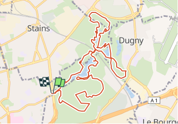

Length
13.5 km

Max alt
67 m

Uphill gradient
160 m
Km-Effort
15.6 km

Min alt
4 m

Downhill gradient
158 m
Boucle
Yes
Creation date :
2019-01-15 19:04:49.985
Updated on :
2023-05-12 13:18:43.984
3h26
Difficulty : Easy

FREE GPS app for hiking
 SityTrail
IGN / Geographical institutes
SityTrail Plus
The world is yours!
About
Trail Walking of 13.5 km to be discovered at Ile-de-France, Seine-Saint-Denis, La Courneuve. This trail is proposed by jpcccb.
Description
Parc de La Courneuve
Positioning
Country:
France
Region :
Ile-de-France
Department/Province :
Seine-Saint-Denis
Municipality :
La Courneuve
Location:
Unknown
Start:(Dec)
Start:(UTM)
455166 ; 5421153 (31U) N.
Comments